
Federated Multi-view Clustering for Remote Sensing Data
Abstract
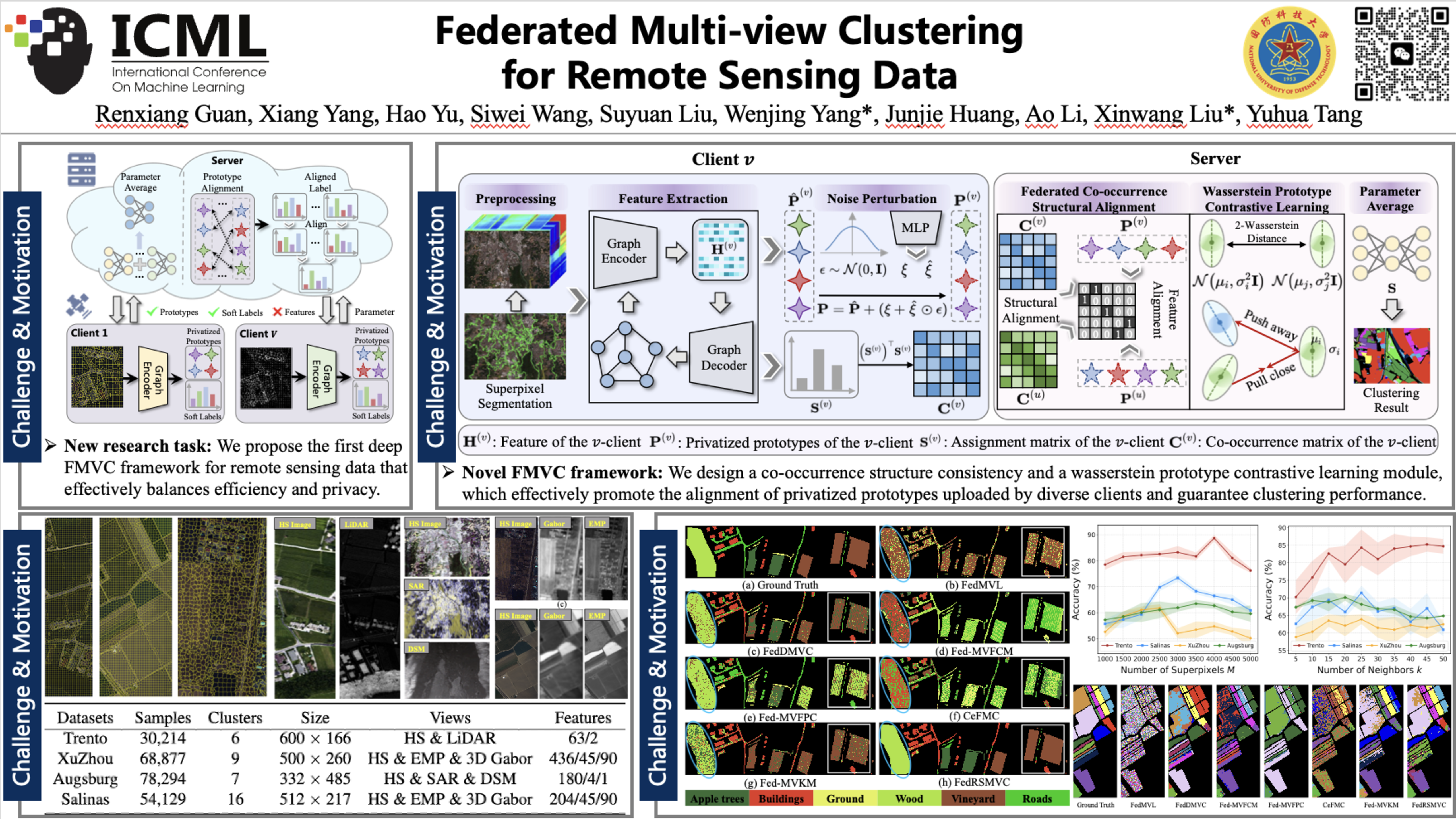
The rapid expansion of remote sensing technology has generated massive amounts of unlabeled multi-view data distributed across different institutions. Analyzing this data presents significant challenges, as centralized processing incurs prohibitive communication costs and raises data privacy concerns. To address these issues, this paper proposes a novel deep federated multi-view clustering (MVC) framework tailored for remote sensing data. Unlike existing methods that transmit sensitive data features, our approach shares only privatized prototypes masked with adaptive noise, ensuring both communication efficiency and privacy preservation. First, we employ superpixel segmentation to reduce the spatial dimensionality of remote sensing data, lowering computational burdens. Furthermore, to resolve the inconsistency of cluster assignments across different clients, we design a co-occurrence structural alignment module that synchronizes local models. Finally, we incorporate a wasserstein prototype contrastive learning mechanism, which models clusters as distributions rather than points, to enhance global consistency and robustness against data heterogeneity. Extensive experiments on four public datasets demonstrate that our framework achieves superior clustering performance and efficiency compared to state-of-the-art methods.
Lay Summary
Modern Earth observation technologies generate massive amounts of multi-view data, capturing diverse modalities like different types of satellite imagery and radar. Because this information is collected by various institutions, it is often siloed in separate, distributed locations. Analyzing all this data centrally is highly impractical due to the prohibitive costs of transmitting such large volumes of data and the strict privacy concerns regarding sensitive geographical information. To address these challenges, we developed a novel federated framework specifically tailored for organizing and analyzing remote sensing data. Instead of sharing raw, sensitive images across a network, our approach allows different institutions to share only "privatized prototypes." These prototypes are essentially abstract summaries of the data that have been purposely masked with adaptive noise to protect privacy. This design entirely avoids the need to transmit raw features, significantly reducing communication bandwidth and computational burdens while keeping data secure. Because local institutions process their data independently, their models can easily become misaligned. To ensure the system works cohesively despite the data remaining isolated, we implemented specialized alignment modules. These tools synchronize the different local models by matching up structural patterns and cluster distributions, ensuring everyone's data summaries align correctly without ever exposing the underlying source information. When tested extensively on four public remote sensing datasets, our framework demonstrated superior clustering accuracy and efficiency compared to existing state-of-the-art methods. Ultimately, this proves that we can effectively and quickly extract valuable insights from distributed Earth data while maintaining strict privacy standards.